|
|
|
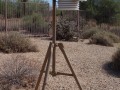
The
heart of
BootieWeather.com
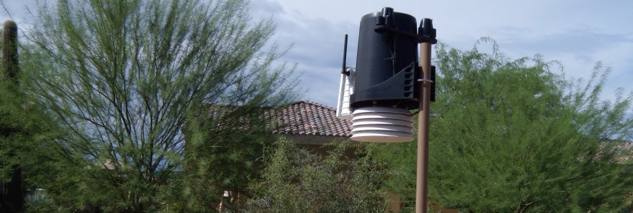
is a Davis Instruments 6162 Wireless Vantage Pro2
with Standard Radiation Shield Weather Station. The
Station is located in North Scottsdale, Arizona at
an altitude of 2061 feet and was originally
installed July 2, 2008.
The Davis Vantage Pro2 console provides forecasting,
on screen graphing and quick view icons that display
28 weather variables on a 4"x6" screen. It is
attached to a data logger. The logger is attached
via a USB cable to a Dell XPS PC with dual hard
drives set in a RAID 1 configuration running Virtual
Weather Station Internet Edition version 14.01 and
WeatherLink version5.8.3. VWS provides current data
to
BootieWeather.com.
Over 320 weather variables are reported, recorded
and retained by the VWS and WeatherLink software.
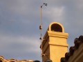
The anemometer, first
installed on a mast 10 feet above ground level with
the rest of the station equipment, was remotely
sited August 12, 2008. It is now attached to a
chimney, 40.4 feet above ground level, the highest
point within a one mile radius. The anemometer
operates independently of the rest of the station
equipment. A small solar power array with battery
backup provides power to the anemometer. A second
small solar power array with battery backup provides
power to the weather station equipment. Both
broadcast wirelessly to the Davis Vantage Pro2
console inside the house. The anemometer was
reposition to ensure accurate wind readings.
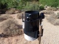
On
October 4, 2009 a Solar Radiation
sensor and an Ultraviolet Radiation sensor were
added to the station array. For improved accuracy,
temperature and humidity sensors are housed inside a
radiation shield. The shield protects against solar
radiation and other sources of radiated and
reflected heat. The solar powered integrated sensor
suite combines all outdoor sensors (rain collector,
anemometer, and temperature, humidity, solar
radiation, and UV sensors) into one package -
improving performance and reliability. The rain
gauge is self emptying. It measures rainfall in .01
inch increments. The station has been calibrated for
height above sea level as well as its longitude &
latitudinal location to seven decimal places.
Boltek StormTracker lightning
detection hardware was installed and configured
October 27, 2010. StormTracker is an add-on to the
stations Dell XPS computer. It not only tells if
lightning is near but lets you see where it is.
StormTracker detects lightning strikes up to 300
miles away and plots them in real time on a custom
made vector format map centered on our back yard.
StormTracker works by
detecting the radio signals produced by lightning.
StormTracker's direction-finding antenna provides
direction information while storm distance is
calculated from received signal strength. Special
processing in software reduces the effects of
strike-to-strike energy variations providing more
accurate distance information. The antenna is
mounted in the attic. The station uses NexStorm a
Microsoft Windows® lightning detection interface
application for the Boltek StormTracker lightning
detector hardware to analyze and display lightning
data. NexStorm seamlessly combines advanced analysis
and display features with Internet integration and
inter-process communication functionality.
NexStorm uploads a data file to BootieWeather.com
every 60 seconds. Once this file has been uploaded,
it is automatically processed by StormVue and the
information contained in the file is displayed in
the applet's graphical user interface. StormVue
allows visitors interactivity through a user
selectable time sequenced animation loop or summary
view, through user selectable range views, full or
zoom range, and interactivity through user
selectable history, 30 or 60 minutes.
January 19, 2011 Began uploading data to StrikeStar
and added a GlobalSat BU-353 GPS unit to my PC to
enable "Precision Timing". In a month we will be
able to add a WASP 2 display (WASP2 stands for Wide
Area Storm Probe) to the station array and upload
it's radar map every 60 seconds to BootieWeather.
Lightning strike data which is detected by different
Boltek lightning detectors in the StrikeStar network
is sent over the internet to a central processing
server which triangulates the data in order to
determine the approximate geographical position of
the lightning strike. The StrikeStar output is
relayed to a companion server application, LDStream,
which in turn feeds this data over a TCP/IP network
and serves as a network access point for the WASP 2
display that will soon be on this site. There will
soon be another lightning display to look at with
triangulated strike data (more accurate data). I
estimate it will take about 60 days to get this
going.
January 21, 2011 BootieWeather is now a member of
the Southwestern Weather Network! You can visit
their site by going to
http://southwesternwx.net.
BootieWeather is listed as Scottsdale in the list of
member stations.
January 23, 2011 BootieWeather is now a member of
the CWOP, NOAA™ Citizen Weather Observer Program,
and contributes data to that network every 10
minutes. Visit BootieWeather page at that site by
going to
http://www.findu.com/cgi-bin/wxpage.cgi?DW3364
January 24, 2011 Added Lightning Archives under Lightning Activity. Visitors can now replay memorable lightning storms!
February 28, 2011 BootieWeather has been accepted into the StrikeStar network and will soon display the WASP2 lightning map with near real time lighting strike as verified and reported by at least two independent Private Weather Stations.
March 4, 2011 Added the WASP2 lightning page that shows lightning strikes within a 50 mile radius confirmed by at least two sources.
March 8, 2011 - Added a UV calculator page to help people determine how long they can be in the sun before they start to burn.
Site developed by Slovak Enterprises
LLC
|
|